

By Eleanor Hart, Senior Policy Analyst
Rain hammered the stone above Edinburgh Castle on 4 July 2021, then water started forcing its way through one of Europe's most recognisable historic sites. What looked, at first, like a violent summer storm was something more specific and more consequential for public policy: a cloudburst.
Table of Contents
- The Deluge Arrives Without Warning
- The Meteorological Mechanism of a Cloudburst
- The Critical Distinction Cloudburst vs Cloud Bursting
- Detecting and Predicting an Impending Cloudburst
- Climate Change and Escalating Cloudburst Risk
- The Cascading Costs to Infrastructure Economy and Governance
- A Policy Roadmap From Response to Resilience
The Deluge Arrives Without Warning
On 4 July 2021, visitors at Edinburgh Castle were dealing with an ordinary summer day until a highly localised storm stalled over the city centre. For roughly 15 minutes, rainfall intensity peaked at 90.8 mm per hour over the castle area. Over the full day, the Royal Botanic Gardens Edinburgh station recorded 57.6 mm, close to four-fifths of the site's average rainfall for the entire month of July. Researchers assessing the event concluded that, under pre-industrial conditions, an episode of this kind would have been expected only rarely, at around a 1-in-120-year probability, and that observed warming had already increased its likelihood by about 30% (American Meteorological Society event analysis).
The immediate damage to the castle's historic fabric was local. The policy signal was not.
For decision-makers asking what is a cloud burst, the defining issue is concentration. A cloudburst compresses large volumes of rain into a very small area and a very short period, creating impacts before conventional emergency protocols have time to scale up. Systems designed around river flooding, seasonal averages, or broad regional forecasts can fail to detect how quickly this hazard moves from meteorology to public liability.
A heritage site became a governance warning
The Edinburgh case shows why cloudbursts should be treated as a governance issue, not only a forecasting issue. Attribution science placed the event within the climate risk discussion rather than outside it, and modelling indicated that further warming would raise the probability again. That detail is significant because it shifts cloudbursts from the category of isolated weather shocks to the category of recurring stress tests for public institutions.
The stress test is multidimensional. Drainage networks can be exceeded within minutes. Transport access can be disrupted before diversion plans are activated. Heritage assets face damage that is expensive to repair and impossible to replace. Municipal authorities must then absorb costs across emergency response, public communication, insurance disputes, infrastructure repair, and budget reprioritisation.
Policy implication: When intense rainfall develops faster than institutions can react, resilience depends as much on governance design as on weather detection.
Why this belongs on multilateral agendas
Cloudbursts expose a persistent blind spot in international climate discussions. G7 and G20 processes often focus on annual losses, long-term adaptation finance, and broad resilience targets. Those frames are necessary, but they can obscure the operational failures that determine whether a city withstands a 15-minute shock.
That is where the ambiguity in the term also becomes dangerous. In policy and business settings, “cloud bursting” can refer to cloud computing overflow into external servers. In meteorology, a cloudburst is a short-duration, high-intensity rainfall event with immediate physical consequences. When governments, regulators, and risk planners use the same phrase imprecisely, they create room for errors in procurement, contingency planning, and crisis communication.
A single cloudburst can disrupt transport, utilities, schools, hospitals, tourism, and emergency services at the same time. The event is geographically narrow, but the governance implications extend well beyond the affected district. For multilateral bodies concerned with disaster risk reduction, climate adaptation, and infrastructure standards, cloudbursts offer a clear test case: whether resilience policy is specific enough to manage sudden, localised extremes rather than only broad climatic trends.
The Meteorological Mechanism of a Cloudburst
A cloudburst forms when the atmosphere stores a large amount of water in a very localised storm system and then releases it abruptly. In UK meteorology, a cloudburst is defined as rainfall exceeding 20 millimetres in a few minutes, generating approximately 20,000 metric tons of water per square kilometre, enough to overwhelm standard drainage capacity, according to the cloudburst definition summary.
That threshold matters because it distinguishes a cloudburst from ordinary heavy rain. The issue isn't only volume. It's concentration in time and space.
How the atmosphere stores and releases water
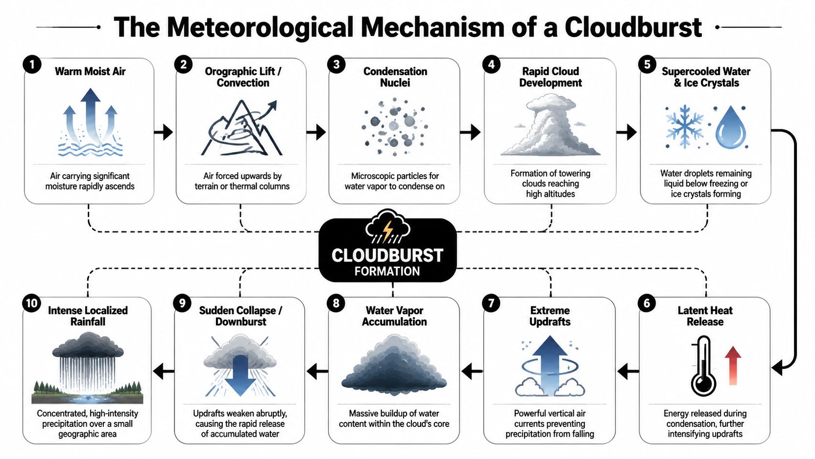
The clearest way to think about a cloudburst is as an atmospheric water balloon. Warm moist air rises rapidly. That ascent can be driven by convection from surface heating or by orographic lift, where terrain forces air upward. As the air rises, water vapour condenses around microscopic particles, building towering storm clouds.
Inside those clouds, strong updrafts can hold water droplets and ice particles aloft longer than usual. Condensation releases heat, which strengthens the upward motion further. The storm then becomes self-intensifying for a period.
A simplified sequence looks like this:
- Moist air ascends: Warm air carrying substantial moisture rises quickly.
- Clouds deepen: Condensation and latent heat release help a storm grow vertically.
- Updrafts trap precipitation: Powerful vertical currents keep raindrops from falling.
- Water accumulates: The cloud core stores more liquid water than local drainage can handle.
- Collapse follows: Once the updraft weakens, the stored water drops in a short, violent burst.
This is why a cloudburst can appear disproportionate to the wider weather picture. One neighbourhood may experience a destructive deluge while nearby districts see much less rain.
Why cloudbursts overwhelm cities so quickly
Urban systems struggle with cloudbursts because design logic often assumes a more distributed rainfall pattern. Pipes, culverts, road cambers, and surface channels can manage substantial water if it arrives over longer periods. They fail when intense runoff arrives almost at once.
A cloudburst is less like a long storm and more like a short infrastructure stress test conducted without notice.
The same mechanism also explains why hilly and mountainous terrain can be especially exposed. Uplift helps create the storm, then gravity accelerates runoff once rain hits the ground. In dense cities, impermeable surfaces produce a different version of the same problem. Water has nowhere to go except roads, underpasses, stations, basements, and low-lying public assets.
For policymakers asking what is cloud burst in practical terms, the answer is straightforward. It is a meteorological event defined not just by rainfall, but by the speed with which the atmosphere converts stored moisture into local flooding.
The Critical Distinction Cloudburst vs Cloud Bursting
Public institutions now operate across climate policy, critical infrastructure, and digital systems. That's one reason language matters more than it seems. The phrase cloudburst refers to an extreme rainfall event. Cloud bursting refers to an IT architecture. They sound similar enough to create avoidable confusion in public documents, procurement language, and resilience planning.
Two similar phrases with different meanings
The policy problem is already visible. The ambiguity between meteorological cloudbursts and IT cloud bursting creates significant confusion in UK disaster risk frameworks and wider G7 climate resilience discussions, as noted in the Cambridge Dictionary cloudburst reference and related definitional discussion. Some definitions also use different rainfall thresholds, which makes standardisation harder.
In practice, the terms belong to separate domains:
| Term | Meaning | Policy domain |
|---|---|---|
| Cloudburst | A short, intense meteorological rainfall event | Disaster risk, climate adaptation, flood management |
| Cloud bursting | A computing method for handling overflow demand | Digital infrastructure, public IT resilience, service continuity |
That distinction might look semantic. It isn't. When agencies draft resilience strategies, search procurement databases, or coordinate across ministries, similar language can fragment responsibility.
Why this matters for public institutions
A ministry of environment, a national meteorological service, and a digital transformation office can all use similar language while discussing different risks. That creates a coordination hazard. One team may be discussing surface water flooding. Another may be discussing server load management. Neither mistake is trivial when emergency doctrine depends on clarity.
The safest institutional response is to specify terms every time they appear in strategic documents. Write meteorological cloudburst when discussing rainfall. Write cloud bursting in computing when discussing hybrid digital capacity. That small discipline improves interoperability between agencies that already struggle to align climate, infrastructure, and technology policy.
Clear definitions are a resilience tool. Ambiguous definitions are a vulnerability.
For G7 and G20 settings, this is more than style. Shared terminology shapes what gets measured, financed, and prioritised. If the language is blurred, the policy signal is blurred too.
Detecting and Predicting an Impending Cloudburst
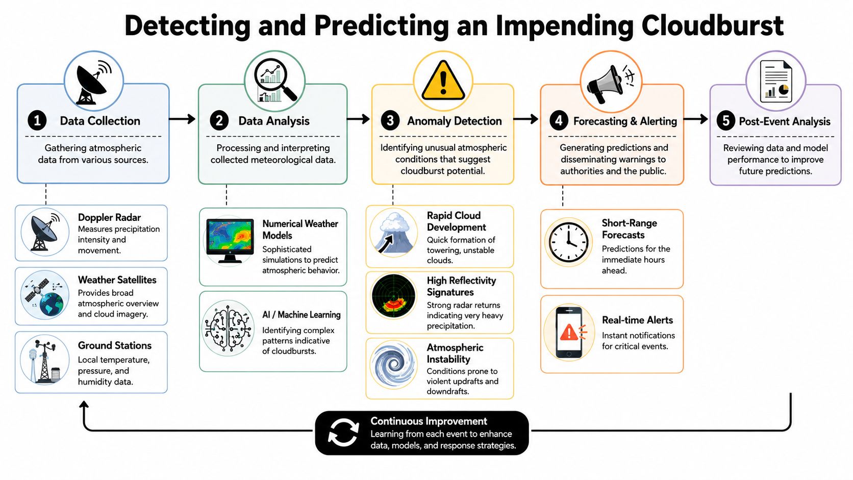
Forecasting cloudbursts is difficult because the event develops fast, remains highly localised, and can intensify between routine forecast cycles. Meteorological agencies rely on a layered approach rather than a single instrument. Doppler radar, weather satellites, ground stations, numerical weather prediction models, and newer machine learning tools each reveal part of the risk picture.
What forecasters can see
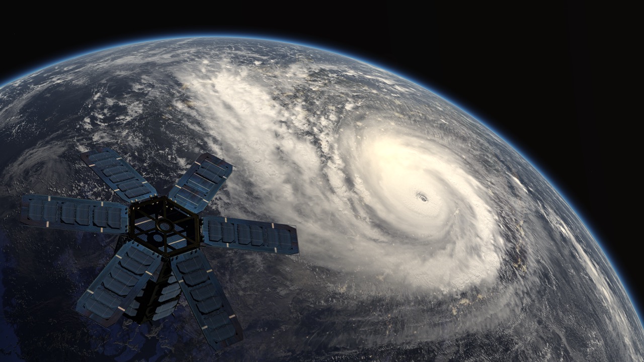
Doppler radar is often the most operationally useful tool once convective storms are forming. It can detect precipitation intensity and movement at fine temporal intervals. Satellites provide the broader atmospheric context, especially cloud growth and moisture patterns. Ground stations supply local measurements that help calibrate what radar and models are showing.
Meteorologists then combine these inputs with short-range models and nowcasting methods. The task is less about naming a cloudburst hours in advance with certainty and more about narrowing the window in which dangerous local rainfall becomes plausible.
Three warning signs usually matter most in practice:
- Rapid cloud development: Towering convective clouds suggest unstable conditions.
- High radar reflectivity: Very strong returns can indicate intense rainfall potential.
- Atmospheric instability: Moist, buoyant air supports strong vertical motion.
For policymakers, the operational takeaway is that warning systems must function across multiple timescales. Strategic resilience is built long before the event, but the final decision to close a road, alert schools, or mobilise drainage crews may hinge on very short-term observational data.
Why lead times remain short
Cloudbursts test the limits of prediction because they are small-scale and nonlinear. A forecast may identify increased risk over a city region while still failing to identify the exact street corridor that will flood first. That's why public communication has to be designed around uncertainty rather than false precision.
A strong early warning system therefore does two things well. It translates technical uncertainty into clear action thresholds, and it links meteorological data to municipal operating decisions. The policy debate on warning systems often focuses on technology acquisition alone. That's incomplete. Institutional protocols matter just as much.
A useful framing appears in this analysis of turning data into decisive action on disaster resilience. The central challenge isn't only collecting more weather data. It's converting detection into decisions that local authorities can execute within minutes.
Forecast value depends on the last mile. If an alert doesn't trigger a usable action, it remains information rather than protection.
Post-event analysis is equally important. Agencies need to review where radar interpretation worked, where alerts arrived too late, and how local responders acted. Cloudbursts punish static systems. Forecasting practice has to learn dynamically if resilience is to improve.
Climate Change and Escalating Cloudburst Risk
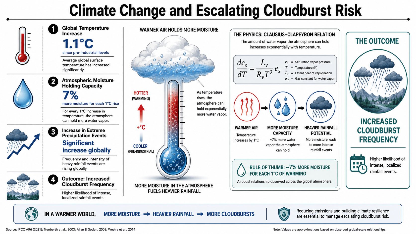
Cloudbursts now sit at the junction of atmospheric science and adaptation finance. Warmer conditions support more moisture in the air, and that raises the likelihood that some storms will release larger amounts of rain over short periods. The climate signal becomes policy-relevant when that physical logic starts showing up in urban damage patterns.
From isolated hazard to systemic risk
The evidence from UK urban areas is already difficult to ignore. The frequency of cloudbursts has doubled in some UK urban areas since 2020, with London experiencing 12 events between 2023–2025, correlating with infrastructure failure costs exceeding £2.3bn for local authorities, according to this discussion of recent UK cloudburst trends.
That matters because it reframes the cloudburst from a rare meteorological curiosity into a recurring urban governance problem. Once local authorities start facing repeated drainage failures, transport disruption, and asset damage, resilience stops being a side topic. It becomes a budget line, a planning rule, and a political accountability issue.
This pattern also exposes a blind spot in multilateral climate debates. Global forums often separate mitigation, adaptation, and disaster response into distinct policy tracks. Cloudbursts don't respect those boundaries. They are adaptation failures in real time, and they often reveal whether infrastructure planning has integrated climate risk at all.
Why G20 resilience planning is lagging
Current G20 urban resilience commitments haven't adequately absorbed this trend. That's a governance problem, not merely a scientific one. If the hazard is intensifying in major cities, then standards for drainage, zoning, and emergency management should be updated with equal urgency.
Some of the most useful lessons may come from adjacent sectors where climate exposure is assessed in operational terms. For readers interested in how risk translation works outside urban infrastructure, this discussion of protecting NY farms from climate risks offers a grounded example of how changing weather patterns reshape insurance, planning, and resilience choices at the asset level.
A parallel governance argument appears in this examination of governing climate risk in a warming world. The most important shift is conceptual. Governments can't treat extreme local rainfall as a residual weather problem while discussing climate adaptation elsewhere. The two are the same agenda viewed at different scales.
For G20 finance and infrastructure ministries, the implication is direct. If cloudburst exposure is increasing, then adaptation frameworks need to move beyond broad pledges and into standard-setting, capital allocation, and municipal implementation support.
The Cascading Costs to Infrastructure Economy and Governance
Cloudbursts rarely stay confined to floodwater. They trigger interacting failures across physical infrastructure, local economies, and public administration. The point for policymakers isn't that one storm causes many inconveniences. It's that a short local hazard can generate simultaneous demand shocks across several systems that are usually budgeted and governed separately.
Infrastructure failure doesn't stay local
Drainage is the first obvious pressure point, but it's rarely the only one. Roads become channels for runoff. Rail stations and tunnels fill. Power or communications assets may be disrupted if water reaches vulnerable nodes. Hospitals, schools, and care facilities can remain structurally intact yet still lose operability if access routes fail.
A useful analogy comes from digital infrastructure. In cloud computing, cloud bursting is a hybrid strategy in which on-premises applications redirect overflow workloads to public cloud services when resource usage reaches a 70–80% threshold, helping maintain service continuity during sudden demand spikes, according to Google Cloud's explanation of cloud bursting. Cities facing cloudbursts need the civic equivalent: overflow capacity in transport management, drainage operations, emergency communications, and local command structures.
That analogy is instructive because it clarifies what resilience means. It doesn't mean building every system for worst-case conditions at all times. It means designing surge pathways before the crisis.
Governance systems face their own surge demand
Economic costs emerge quickly even when national headlines focus only on visible flood damage. Shops close. Commuters can't move. Deliveries stall. Local authorities face emergency spending before they've even completed damage assessment. Insurance disputes, public complaints, and political scrutiny arrive at the same time.
The governance strain usually follows three channels:
- Operational pressure: Emergency services, highways teams, and local utilities all face concurrent calls on staff and equipment.
- Fiscal pressure: Municipal budgets absorb immediate response costs while longer-term repair liabilities accumulate.
- Institutional pressure: Public trust weakens when warnings are unclear or infrastructure appears visibly unprepared.
Decision rule: Treat cloudbursts as compound governance incidents, not isolated weather emergencies.
This is why resilience planning should not sit only within environment ministries. Finance departments, infrastructure agencies, civil protection bodies, and digital service teams all have a stake. A cloudburst can expose fragmented responsibilities more efficiently than any audit.
The broader strategic point is simple. The cost of a cloudburst isn't limited to the rainfall footprint. It expands through the systems that fail to absorb shock.
A Policy Roadmap From Response to Resilience
The core policy mistake is to treat cloudbursts as unavoidable local disasters rather than manageable governance risks. They can't be prevented entirely, but their consequences can be reduced sharply when standards, finance, land use, forecasting, and public communication are aligned.
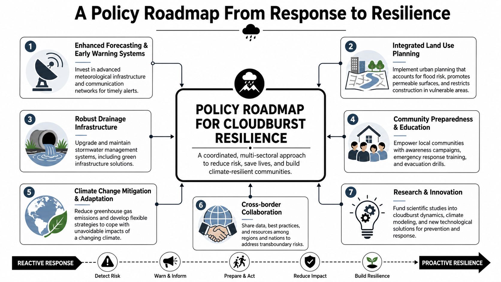
What multilateral forums should do now
G7 and G20 processes are well placed to solve the cross-border parts of the problem. They should focus on policy architecture rather than local operational detail.
Priority actions include:
- Standardise terminology: Governments need common definitions for meteorological cloudbursts so risk assessments and adaptation plans are comparable.
- Align resilience finance: Multilateral development banks and climate funds should support urban drainage upgrades, forecasting systems, and risk-informed land use reform.
- Share operational practice: Meteorological agencies and civil protection bodies should exchange methods for nowcasting, warning design, and municipal response protocols.
- Embed cloudburst risk in urban agendas: Extreme local rainfall should be explicit in infrastructure and resilience communiqués, not implied under generic flood language.
A strong framing for that shift appears in this argument for placing disaster risk at the core of the G7 agenda. Disaster risk reduction works best when it is integrated into fiscal and infrastructure governance, not treated as an annex.
What national governments should change
National action has to be more practical. Governments should revise drainage and urban design standards, update risk maps, and ensure meteorological alerts trigger predefined local authority actions. They should also clarify institutional ownership. If no ministry owns cloudburst resilience end to end, it won't be delivered coherently.
A compact national checklist looks like this:
- Upgrade forecasting capability with better radar interpretation, nowcasting, and local dissemination protocols.
- Reform planning rules so new development reflects current rainfall risk rather than outdated assumptions.
- Invest in drainage resilience using both conventional engineering and nature-based urban water management where suitable.
- Run public communication campaigns so residents, schools, and businesses know how to respond to rapid local flooding.
- Review critical assets including hospitals, transport nodes, schools, and heritage sites for cloudburst exposure.
The strategic conclusion is unavoidable. If governments keep treating cloudbursts as freak events, losses will remain politically surprising and fiscally disruptive. If they treat them as an emerging resilience benchmark, they can act earlier, spend smarter, and protect more effectively.
Global Governance Media helps decision-makers connect climate risk, disaster resilience and multilateral policy with clear, evidence-led analysis. Explore more reporting and expert insight at Global Governance Media.